While we cannot answer this question simply with yes or no, we can say that there is a strong indication that Hurricane Gert will have an effect on the weather in Central Europe at the end of this week. Currently, Gert is located as a Category-1 Hurricane over the western North Atlantic. As it is moving northward, Hurricane Gert will lose its tropical characteristics and it will transform into a midlatitude low pressure system. This process is referred to as extratropical transition (ET).
While undergoing ET, Hurricane Gert is going to interact with the upper-tropospheric midlatitude flow, i.e., the flow at about 9-12 km height. At this height, the midlatitude flow is characterised by bands of strong westerly winds – the so-called jet streams (you have probably been flying in these jet streams when crossing the Atlantic in a plane from west to east). Currently the jet stream over the North Atlantic is quite zonally oriented from west to east with wind speed reaching 200-225 km per hour.
… Hurricane Gert acts as a wave maker, similar to a rock that generates waves when being dropped into water.
During the interaction of Hurrlcane Gert with the jet stream, the band of strong winds gets deflected northward and the wind speed increases gradually to more than 275 km per hour on Friday. The winds at 9-12 km height are predicted to be strongest in a northerly flow west of the British Isles. In response to the northward deflection of the jet streams, further deflections of the westerly wind band occur downstream (further east), describing a wave which is referred to as Rossby wave. This wave is reflected by a strong southerly flow of more than 250 km per hour at 9-12 km height over northern Germany and Denmark.
Thus, the flow evolution suggests that the Hurricane Gert acts as a wave maker, similar to a rock that generates waves when being dropped into water. Research has shown that Rossby waves triggered by Hurricanes can lead to extreme weather events quite remotely from the storm itself. For the European region this has been nicely documented in this scientific article by Grams and Blumer (2015).
The northerly flow west of the British Isles and the southerly flow over Germany and Denmark describe a so-called trough. Dynamical processes ahead of this trough lead to the lifting of air which may result in the formation of clouds and rain. Under the conditions of high moisture availability and warm air near the surface, even thunderstorms can develop. Recent forecast are suggesting that thunderstorms and strong rain will develop ahead of this trough over the next 48 hours. In particular, the forecast indicate strong rain over the Alpine region in the night from Friday to Saturday. Early warnings have been issued by the Swiss Federal Office of Meteorology and Climatology for mountaineous regions in expectation of 40-60 liters of rain.
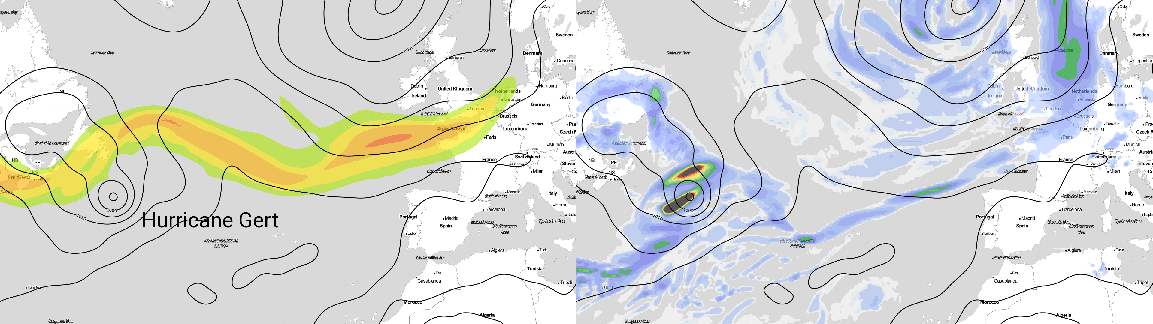
Fig 1: GFS forecast for 17/08/2017 06 UTC to 19/08/2017 06 UTC showing wind speed at 250 hPa (left), 6 hourly precipitation (right) and mean sea level pressure (black contours, left & right).
Try Weatheroo’s Weathermaps yourself to see how the weather is developing in your region.